Nevada County Census Block Groups (CGBs) and Broadband Internet Service
Like most every project, the story of internet in Nevada County, Arkansas follows the available funding:
- In the early days, before there were big grants, a few Internet Service Providers (ISPs) had "dial-up" service. The Prescott Community Freenet Association, a not-for-profit organization, obtained funding from local clubs and governments and became the first in Nevada County to offer the service from July 1995 to September 1999. In February 1998, IOCC.com provided the first commercial service in Prescott, followed several months later by EZclick.net.
- IOCC provided some early broadband service in part of Prescott utilizing a point-to-multipoint wireless system. A little later, CenturyLink began offering DSL-delivered service and CableLynx began offering cable-delivered service in their service areas.
- Several rounds of grants made it possible for some ISPs to start building fiber-optic based networks that provided the first levels of "broadband" internet. Among these programs were the Coronavirus Aid, Relief, and Economic Security Act (ARConnect-CARES), the American Rescue Plan Act (ARConnect-ARPA), and the Connect America Fund Phase II (CAFII).
- Most recently, the Rural Digital Opportunity Fund (RDOF) provided funding to some ISPs for some locations.
- Beginning in mid-2026, an ISP will be funded to serve "every" underserved and unserved location. This comes from the Broadband Equity, Access, and Deployment (BEAD) grants which were made possible by President Biden's bipartisan Infrastructure Investment and Jobs Act of 2021.
Funding has traditionally followed Census Block Groups, of which there are eight in Nevada County. Geo-political boundaries are often the reason that ISPs do not extend service just a bit further, which is often why a specific location will have internet, but the location "next door" will not have any service. Also, service is usually provided in the area closest to the current service, then builds further away when funding is available.
You may want to zoom in and/or scroll in on the map when your location is close to a boundary.
Northeast and East Central Nevada County
East of Nevada 249 then north of Nevada 41, Nevada 408, Nevada 16, east of Lackland Road (Nevada 290) to a point just south of Caney Creek then south of a westward line to Caney Creek, then east of Caney Creek, north of Nevada 76 and US 278 to the Ouachita County and Clark County lines. Includes part of Redland, Bluff City, and Young.
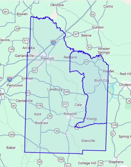
East of Nevada 249 then north of Nevada 41, Nevada 408, Nevada 16, east of Lackland Road (Nevada 290) to a point just south of Caney Creek then south of a westward line to Caney Creek, then east of Caney Creek, north of Nevada 76 and US 278 to the Ouachita County and Clark County lines. Includes part of Redland, Bluff City, and Young.
Current Broadband Internet:
See only this CBG
- South Central Connect already serves its electrical customers and the Bluff City area with broadband internet.
- South Central Connect has RDOF funding for some of this area.
- RDOF grants must be completed within six years of the award date, so that means before the end of 2028.
- SpaceX is the BEAD grant selectee for the 62 unserved, underserved and unfunded locations in this area, the Nevada County portion of Project Area Footprint 238.
- BEAD grants must be completed within four years of the award date, so that means before the end of 2030.
- President Trump's "Benefit of the Bargain" replaced the originally-planned fiber optic service for these 61 locations with low earth orbit (LEO) satellite service, which is generally regarded as having lower speed potential and carrying a much higher price for end users than that of fiber optic service.
- The Nevada County Broadband Committee has grave concerns for permanently impaired internet service to these 10 locations
because BEAD and other grants did not provide the funding and ISPs may never find other means to extend
fiber optic internet service:
- 116 Highway 368, Prescott
- 124 Ada Street, Reader
- 166 County Road 424 (Buster Green Road), Bluff City
- 252 County Road 447 (Joey Pittman Road), Rosston
- 140 Nevada 46, Rosston
- 1244 County Road 46, Rosston
- 144 Nevada 429, Rosston
- 1011 Nevada 16, Prescott
- 1107 County Road 16, Prescott
- 238 Lackland Road (Nevada 290), Prescott (appears to be misplaced on map, and if it's in SCC area, it's OK)
- The Committee has concern about the impairment of internet service for the remaining 51 locations until
private ISPs find other means to extend fiber optic services, which we believe will happen in time:
- Nevada 249, 9 locations (739, 749, 751, 767, 809, 903, 945, 951, and 1032), are across the road from Brightspeed BEAD Grant locations.
- Highway 24, 18 locations (2480, 2518, 2576, 2636, 2704, 2898, 2914, 2946, 3187, 3210, 3218, 3250, 3256, 3272, 3328, 3370, 3435, and 3448), are across the highway from RDOF grants to South Central Connect. The first few are close to Nevada 249 are adjacent to Brightspeed BEAD Grant locations.
- Nevada 409, 3 locations (224, 226 and 246), are not far from current South Central Connect RDOF locations on the road and across Highway 24.
- 157 Nevada 290 is across the road from South Central Connect RDOF funding.
- 100 Nevada 173 Bldg 2 is about 1/2 mile from 100 Nevada 173 RDOF funded to South Central Connect.
- Highway 76, 5 locations (585, 607, 679, 1015 and 1107), are across the road from Brightspeed BEAD or just down the road between other funded locations.
- Nevada 171 (Berry Road), 14 locations (149, 159, 169, 179, 213, 214, 219, 293, 299, 299 Bldg 2, 507, 511, 541, and 541 Bldg 2), are just north of Waterloo and other Brightspeed BEAD grant locations.
- Brightspeed provides telephone service in parts of this area. It is likely to offer broadband internet service when it converts from copper to fiber optic lines.
See only this CBG
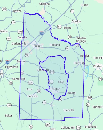
Central Nevada County
East of US 371 and south of Terre Rouge Creek, east of Nevada 287, south of Nevada 278, north of Nevada 36, west of Caney Creek and Lackland Road, south of Nevada 16, Nevada 408 and Nevada 41. Includes Laneburg east of 371, Morris, Cale, Waterloo, Oak Grove, and Rosston.
 Current Broadband Internet:
See only this CBG
East of US 371 and south of Terre Rouge Creek, east of Nevada 287, south of Nevada 278, north of Nevada 36, west of Caney Creek and Lackland Road, south of Nevada 16, Nevada 408 and Nevada 41. Includes Laneburg east of 371, Morris, Cale, Waterloo, Oak Grove, and Rosston.
- South Central Connect already serves its electrical customers with broadband internet.
- South Central Connect has RDOF funding for some of this area, some of which is not yet complete.
- RDOF grants must be completed within six years of the award date, so that means before the end of 2028.
- Brightspeed is the BEAD grant selectee for 111 unserved, underserved and unfunded locations in this area, the Nevada County portion of Project Area Footprint 182. Service will be provided via fiber optic cable.
- BEAD grants must be completed within four years of the award date, so that means before the end of 2030.
- Brightspeed provides telephone service in parts of this area. It is likely to offer broadband internet service when it converts from copper to fiber optic lines.
See only this CBG
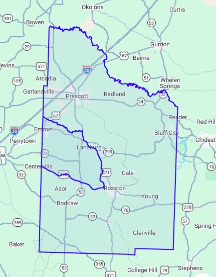
West Central Nevada County
South of Terre Rouge Creek, west of US 371 and Nevada 287, north of US 278 to the Hempstead County line. Includes Emmet, Laneburg west of 371, Mt Moriah church, USAF MARS station, and Forest Hill.
 Current Broadband Internet:
See only this CBG
South of Terre Rouge Creek, west of US 371 and Nevada 287, north of US 278 to the Hempstead County line. Includes Emmet, Laneburg west of 371, Mt Moriah church, USAF MARS station, and Forest Hill.
- Cablelynx already serves Emmet with broadband internet. It has completed construction of projects funded by ARConnect - CARES.
- South Central Connect already serves its electrical customers with broadband internet.
- South Central Connect has RDOF funding for some of this area, some of which is not yet complete. CAFII Auction funding is complete.
- RDOF grants must be completed within six years of the award date, so that means before the end of 2028.
- Amazon Kuiper (now called Amazon LEO) is the BEAD grant selectees for 3 unserved, underserved and unfunded locations in this area, the Nevada County portion of Project Area Footprint 256. Service will be provided by low earth orbit (LEO) satellite.
- BEAD grants must be completed within four years of the award date, so that means before the end of 2030.
- President Trump's "Benefit of the Bargain" replaced the originally-planned fiber optic service for these 3 locations with low earth orbit (LEO) satellite service, which is generally regarded as having lower speed potential and carrying a much higher price for end users than that of fiber optic service.
- The Nevada County Broadband Committee feels there is already reasonable broadband available at the three
Community Anchor Institutions (CAIs), unless the 1000 upband speed is needed, in which case the lack of
funding for fiber optic service becomes a permanent impairment:
- Emmet Fire Station - Cablelynx offers up to 1000/50 service.
- Laneburg Volunteer Fire Department Station 1, South Central Connect offers up to 1000/500 service.
- Laneburg Volunteer Fire Department Station 2, South Central Connect offers up to 1000/500 service.
- No residences or businesses were identified in 2025 as needing BEAD funding.
- Brightspeed provides telephone service in parts of this area. It is likely to offer broadband internet service when it converts from copper to fiber optic lines.
See only this CBG
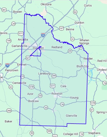
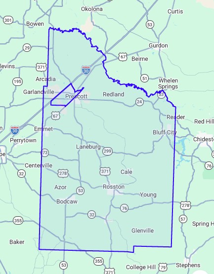
Prescott East
Most of city of Prescott east of the railroad tracks. Excludes east of Cale Road, east of East Main and East 5th Streets, and the McRae school area. Includes area south of the city north of Nevada 51 and Nevada 28, but only west of Nevada 50 and Nevada 23.
 Current Broadband Internet:
See only this CBG
Most of city of Prescott east of the railroad tracks. Excludes east of Cale Road, east of East Main and East 5th Streets, and the McRae school area. Includes area south of the city north of Nevada 51 and Nevada 28, but only west of Nevada 50 and Nevada 23.
- Cablelynx, South Central Connect and Brightspeed already serve Prescott and some of the surrounding area with broadband internet.
- South Central Connect has RDOF funding for some of the areas surrounding the Prescott city limits that is not yet complete.
- Brightspeed is the BEAD selectee for the unserved, underserved and unfunded locations in this area, including several Community Anchor Institutions (CAIs) which did not have the 1000/1000 at the time the locations were being finalized, part of Project Area Footprint 077 which includes 533 locations in northern and southeastern Nevada County. Service will be provided via fiber optic cable.
- BEAD grants must be completed within four years of the award date, so that means before the end of 2030.
- It is likely that Cablelynx, South Central Connect and Brightspeed will extend their services in coming years, with Cablelynx converting to fiber optic delivery.
See only this CBG
Prescott West
City of Prescott west of the railroad tracks. Also includes south of the city north of Nevada 26, east of I-30 to Arkansas 19 and south of Garland Creek to the railroad tracks.
 Current Broadband Internet:
See only this CBG
City of Prescott west of the railroad tracks. Also includes south of the city north of Nevada 26, east of I-30 to Arkansas 19 and south of Garland Creek to the railroad tracks.
- Cablelynx, South Central Connect and Brightspeed already serve Prescott and some of the surrounding area with broadband internet.
- South Central Connect has RDOF funding for some of the areas surrounding the Prescott city limits that is not yet complete.
- Brightspeed is the BEAD selectee for the unserved, underserved and unfunded locations in this area, including several Community Anchor Institutions (CAIs) which did not have the 1000/1000 at the time the locations were being finalized, part of Project Area Footprint 077 which includes 533 locations in northern and southeastern Nevada County. Service will be provided via fiber optic cable.
- BEAD grants must be completed within four years of the award date, so that means before the end of 2030.
- It is likely that Cablelynx, South Central Connect and Brightspeed will extend their services in coming years, with Cablelynx converting to fiber optic delivery.
See only this CBG
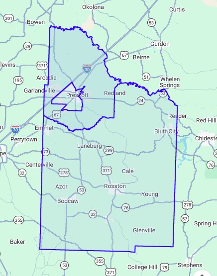
Northern Nevada County Except Prescott
Except for Prescott East and Prescott West, the northern part of Nevada County. North of Little Terre Rouge Creek and Terre Rouge Creek, north of Nevada 41, then west of Nevada 35 to the Hempstead County, Pike County and Clark County lines. Includes Boughton, part of Redland and bits of Prescott.
Except for Prescott East and Prescott West, the northern part of Nevada County. North of Little Terre Rouge Creek and Terre Rouge Creek, north of Nevada 41, then west of Nevada 35 to the Hempstead County, Pike County and Clark County lines. Includes Boughton, part of Redland and bits of Prescott.
Current Broadband Internet:
See only this CBG
- South Central Connect already serves its electrical customers with broadband internet.
- On December 31, 2025, South Central Connect notified the FCC that it will default on its obligations for RDOF funded locations in this area. That leaves these locations unserved and without funding for service. Glen Howie, Director of Arkansas Broadband Office, told us in an e-mail "We believe NTIA is going to allow states to run a 'clean-up' round with BEAD funds for defaulted locations, but there has not been official guidance released at this time."
- Brightspeed is the BEAD selectee for the unserved, underserved and unfunded locations in this area, part of Project Area Footprint 077 which includes 533 locations in northern and southeastern Nevada County. Service will be provided via fiber optic cable.
- BEAD grants must be completed within four years of the award date, so that means before the end of 2030.
- Brightspeed provides telephone service in this area. It is likely to offer broadband internet service when it converts from copper to fiber optic lines.
- It is possible that Cablelynx will expand outside their current service area over the coming years.
See only this CBG
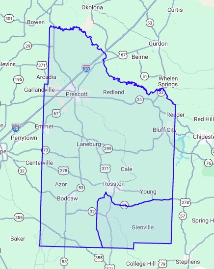
Southeastern Nevada County
East of Nevada 17 and south of Nevada 36, west of US 371, south of Nevada 76, and south of US 278 to the Ouachita County and Columbia County lines. Includes Troy, Glenville, Mt. Olive, Pleasant Grove, Pleasant Hill.
East of Nevada 17 and south of Nevada 36, west of US 371, south of Nevada 76, and south of US 278 to the Ouachita County and Columbia County lines. Includes Troy, Glenville, Mt. Olive, Pleasant Grove, Pleasant Hill.
Current Broadband Internet:
See only this CBG
- There are no broadband ISPs currently serving this area.
- Centurytel of NW Arkansas (now Brightspeed) has RDOF funding for some locations in this area, but has completed any service.
- RDOF grants must be completed within six years of the award date, so that means before the end of 2028.
- Brightspeed is the BEAD selectee for the unserved, underserved and unfunded locations in this area, part of Project Area Footprint 077 which includes 533 locations in northern and southeastern Nevada County. Service will be provided via fiber optic cable.
- BEAD grants must be completed within four years of the award date, so that means before the end of 2030.
- Brightspeed provides telephone service in this area. It is likely to offer broadband internet service when it converts from copper to fiber optic lines.
See only this CBG
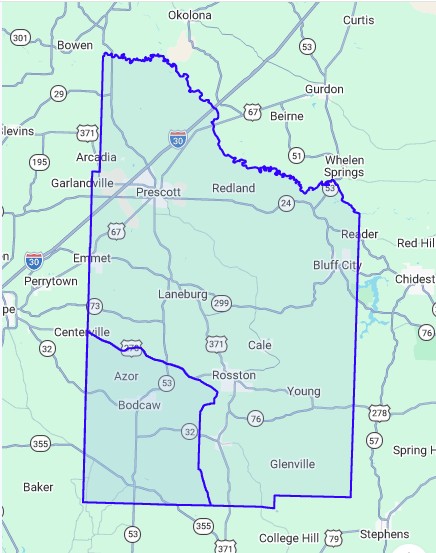
Southwestern Nevada County
South of US 278 and west of Nevada 17 to the Hempstead County and Columbia County lines. Includes Azor, Union, Bodcaw, Whites Chapel, Shiloh, Falcon, and Clevet Springs.
Current Broadband Internet:
See only this CBG
- Walnut Hill Telephone already serves its telephone customers in and around Falcon with broadband internet. It has completed construction of projects funded by ARConnect - ARPA / Arkansas Rural Connect (ARC).
- South Central Connect already serves its electrical customers in the area with broadband internet.
- Walnut Hill Communications has completed construction of ARConnect-ARPA funded projects in this area.
- South Central Connect has completed construction of RDOF funded projects in the area.
- SpaceX is the BEAD grant selectees for 3 unserved, underserved and unfunded locations in this area, the Nevada County portion of Project Area Footprint 254. Service will be provided by low earth orbit (LEO) satellite.
- BEAD grants must be completed within four years of the award date, so that means before the end of 2030.
- President Trump's "Benefit of the Bargain" replaced the originally-planned fiber optic service for these 3 locations with low earth orbit (LEO) satellite service, which is generally regarded as having lower speed potential and carrying a much higher price for end users than that of fiber optic service.
- The Nevada County Broadband Committee has grave concerns for permanently impaired internet service to these 3 locations
because BEAD and other grants did not provide the funding and ISPs may never find other means to extend
fiber optic internet service:
- Texas Eastern Transmission facility at 227 County Road 112 and 393 Nevada 112
- The residence at 146 County Road 138, which is just a few hundred feet from Columbia County
- These 3 locations may have been omitted from the fiber deployment of South Central Connect because they likely receive power from Entergy instead of the South Central Electric Cooperative.
- Since portions of this area are in Brightspeed's telephone service area, those locations are likely to have broadband internet service when the company converts copper lines to fiber.
See only this CBG
Source for the KML data that outlines this map is from Tiger at U.S. Census: https://www.census.gov/geographies/mapping-files/time-series/geo/kml-cartographic-boundary-files.html.
